Text by Sinan Logie and Yoann Morvan
The two contributions presented here shed light on the ongoing urban mutation of the Bosphorus megalopolis. They present two facets of the so-called “urban transformation” policy (“kentsel dönüşüm” in Turkish) at work in Istanbul. The policy is of considerable significance and has thus increasingly attracted the attention of the social sciences1 that for too long over-focused on Sulukule2. Launched more than a decade ago by the Turkish authorities, the “kentsel dönüşüm” gained momentum after the 2012 Anti-seismic Law that aims to “replace” hundreds of thousands of residential buildings in order to meet with earthquake resistance regulations. This “urban transformation” plays a major role in creating new urban polarities through the renewal of the housing stock and above all the increase in land values. The two photographic perspectives presented here are critically complementary. The first series of pictures, in Fikirtepe, crudely unveils destruction at the hands of the policy. Meanwhile the second one, in Başakşehir, quietly observes the new urban model that emerges from this metamorphosis orchestrated by the elite.
North of the Kadıköy district, one of the central polarities of the Anatolian bank, Fikirtepe, illustrates the urban (un)-building of Istanbul.3 Introduced in 2010 as an “urban transformation” area by the Metropolitan Municipality of Istanbul, this urban sector quickly began to sink into a swamp of speculation. The site of Fikirtepe carries a long history of human settlement. Inhabited since the Neolithic4 period, this site was a privileged spot for mesire (a site used by the bourgeoisie for picnics and promenades) during the Ottoman era due to its closeness to the Kurbağlıdere river. The current configuration of the neighborhood relies on migratory dynamics rooted in the country’s industrialization over the second half of the 20th century.
“Fikirpete is an outstanding illustration of the urban segregation at work in the Bosphorus metropolis”
The highways that give access to the first bridge over the Bosphorus demarcate Fikirtepe on its three sides. Southern Fikirtepe, abutting the upper-class sector of Kadıköy, is a typical case-study of local urban margins and micro-spatial segregation in Istanbul. The existing small factories along the E-5 urban highway (connected to the first bridge over the Bosphorus) and the service-sector job market of wealthy districts of Kadıköy and Moda explain the presence of workers coming from rural migrations. In the absence of a social housing policy, migratory flows in Istanbul led to informal developments. Implemented with the tacit agreement of the authorities, these gecekondu (literally “laid at night5”) form about 60% Istanbul’s built edifices. As in Fikiperte, the high seismic risk to buildings is a strategic boon to the authorities. The latter, concerned with supporting the construction sector activities, concocted a series of laws. The formation of legal tools provided real leverages for the Ministry of Urbanism and Environment, as well as municipalities, to initiate colossal land transactions under the guise of “urban transformation”. Meaning, for the authorities, the ability to deeply reconfigure the social and urban fabric of the targeted zones.
As for the over-studied case of Sulukule6, Fikirpete is an outstanding illustration of the urban segregation at work in the Bosphorus metropolis. The new master plan of the neighborhood envisions an increase in density from 10% to 80% depending on the parcel. The master plan came into effect in January 2010. Knowing that the project concerns territory made of 61 blocs with a total of 15,000 buildings, real estate developers promptly went to negotiate profitable operations with local small owners7. This upmarket is made possible at the expense of initial inhabitants, incapable of supporting the cost of future luxury buildings. On their side, developers made no secret of their desire to turn Fikirtepe into an Anatolian Manhattan. The future residencies’ names, “Loft” or “Brooklyn”, are symptomatic of this trend, even though their height will be limited to 80 meters…
In parallel to the negotiations between developers and owners, the Turkish Chamber of Architects took the Fikirtepe initial master plan to court stating that the plan failed to respect the legally defined urban densities. The Turkish Chamber of Architects won its case in 2011. The Metropolitan Municipality of Istanbul voted and approved a new plan, with substantial modifications in September 2011. In January 2014, among the 61 blocks, only four were in the process of building, while among the 15,000 buildings, 3,000 were demolished and 5,000 vacated. The latter have turned into shelters for people involved in criminal activity or Syrian refugees, raising concerns and sparking turmoil amongst owners who have not yet succeed to conclude their negotiations.
Fikirtepe by Salih Mülayim


With real estate benefits, gentrification and the relocation of certain minorities, the (un)-building of Istanbul is in full swing, establishing Turkey as the leading European producer of cement. The question remains as to how to observe the ways in which authorities, in the coming years, will seek to silence the increasing dissident voices of the victims of this social unmaking, first the renters. This dynamic actively plays a role in pushing Turkey towards taking the lead in another European ranking: that of social inequality…
Offering a double perspective of the (un)-building of Istanbul, both Salih Mulayim, who lives in the Kadıköy district and Nicolas Brodard, who spent days in Başakşehir looking for the perfect space-time to capture the shooting he imagined, show a firm knowledge of their respective photographic fields. We can only praise them for their remarkable work on these ongoing urban transformations. Their contributions shed a very different light on Istanbul, one far from the fashionable cliché, when it comes the Bosphorus metropolis, subject of all sort of branding campaigns.
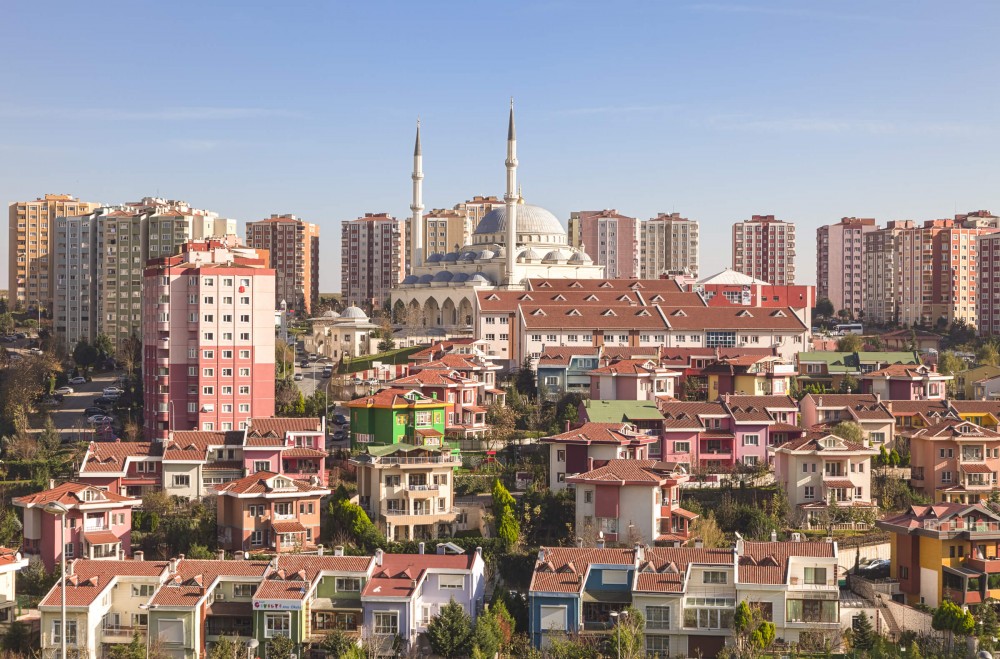
“Başakşehir appears as a modelof the AK Party desired urbanity”
Başakşehir, a satellite city located North-West of the Greater Istanbul, appears as a model8 of the AK Party desired urbanity: neat space, largely sanitized (a salient aspect made visible by Nicolas Brodard’s pictures), clocked by consumption, devoted to a moral order pushed by a new middle-class linked to the party that dominates the Turkish political scene for over a decade. The authorities perceived this “TOKIstan” as a sort of laboratory. Urbanization of this district started in 1985 while it was outside of the Metropolitan Municipality of Istanbul boundaries. It was carried out in several stages.
During the first stage, from 1985 to 1993, 15,000 residences were built. But more importantly, it is after 2001 that Başakşehir, the “cob-city” started to take its current form. Indeed, under the auspices of the AK Party, from 2002 to 2008, urban areas started to extend significantly. Since then, the urban expansion has acquired dramatic dimensions, as the territory is peppered by various “Chinese style” building-clusters. The new district is nowadays the greatest one in terms of gated communities of the Greater Istanbul. The photographic diptych accurately reflects two significant facets of a metropolis that has become a “mega-machine9” in producing the “Excluded10”.
Başakşehir by Nicolas Brodard


Notes
- As shown in the recent multi-sited study published under the direction of Asuman Türkün. Mülk, Mahal, İnsan : İstanbul’da Kentsel Dönüşüm, 2014. ↩︎
- Located within the walls of Istanbul, this neighborhood suffered forced evictions in 2006. ↩︎
- Duygu Parmaksizoglu, “From Home to Real Estate: Urban Redevelopment on the Axis of Speculation in Istanbul“, Jadaliyya, October 2014. ↩︎
- Archaeological excavations revealed that Fikirtepe has been an inhabited site in Istanbul since the Neolithic period (-5500 BC, we generally speak about the Fikirpete’s culture). It is believed that the Kalamıṣ bay extented, at that time, to Fikirtepe, enabling fishing for its inhabitants. Nowadays, the district is 2.5 km away from the coast. ↩︎
- This word refers to self-built house in Turkish urban areas, with its derivative Apartkondu for small buildings. ↩︎
- As well as Sukukule, part of Fikirtepe was, and is still inhabited by Roms, a population encountering segregation even more than others… ↩︎
- The most common model here is a distribution set up as follows: 60% of newly built surfaces go to the owners (who have merged their parcels), while developers make their benefit out of selling the 40% they are allocated. ↩︎
- Jean-François Pérouse, “Başakşehir (Istanbul), la “ville-épi”: de la marge urbaine épiphénomène au modèle urbain hégémonique”, in Nora Semmoud, Bénédicte Florin, Olivier Legros & Florence Troin (eds.), Marges urbaines et néolibéralisme en Méditerranée ↩︎
- Gilles Deleuze and Félix Guatarri (1980), Mille Plateaux, Paris: Minuit ↩︎
- Tahsin Yücel (2012), Gratte-ciel, Paris: Actes sud ↩︎